Explore Washington State's Wildlands in Google Earth
Introduction
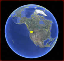
We have mapped all the wildlands in Washington State (on all ownerships). You can read about it in our 1998 report titled "Unprotected Wildlands of Washington State." You can also explore these wildlands using Google Earth.
To do this, first you have to download and install Google Earth on your computer. If you have not already done this, you should really consider doing it now. Google Earth is one of the most amazing software products that man has created. It is a free download from Google and it will let you fly over and explore in great detail ANY PLACE on this planet. It will also allow you to explore outer space in ways that you have never been able to before. To download Google Earth follow this link.
Now that you have Google Earth on your computer, let's explore the protected and unprotected wildlands of Washington State.
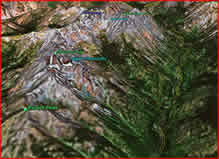
To do this, all you have to do is click on this link. This will open a Google Earth KML file that will fly you to Washington State and you will see all the wildlands outlined in yellow. You can zoom into any one area and see them in more detail. If you zoom way in, you can often see individual trees, rocks, snowfields, lakes, rivers and other features. You can go into 3D mode in Google Earth where you turn on the topography layer and then tilt into a 3D oblique view. Then you can fly around the area as if you are in a plane.
You can get attributes of the wildland area by clicking on it and information on the ownership, environmental characteristics, biological characteristics and recreational attributes may appear.
Copyright © 2009 Pacific Biodiversity Institute
PO Box 298, 517 Lufkin Lane
Winthrop, WA 98862 509-996-2490