GIS Internet Map Server
You may need the following instructions to find your way. We recommend that you print these instructions so that you will not need to return to this page. If you already know how, click here.
Within the applet frame the following tools are available:
 Select
the action you wish to perform and then click on the map. For
panning, the point where you click
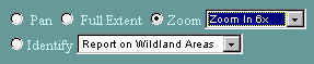
Select
the action you wish to perform and then click on the map. For
panning, the point where you click 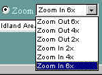 on
the map becomes the center of the new view. For zooming, the map
zooms in or out from the point where you click. You can zoom in or
out by different amounts by selecting it from the drop down menu.
You may return to the original view at any time by clicking the full
extent button
on
the map becomes the center of the new view. For zooming, the map
zooms in or out from the point where you click. You can zoom in or
out by different amounts by selecting it from the drop down menu.
You may return to the original view at any time by clicking the full
extent button
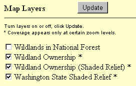 You
can add or remove layers to the map view by checking the box to the left
of the layer name and clicking the "Update" button.
You
can add or remove layers to the map view by checking the box to the left
of the layer name and clicking the "Update" button.
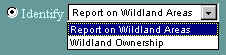 To
see a report of any wild area, click on the Identify tool, select
"Report on Wildland Areas" from the drop-down menu and click on
the roadless area in the map. NOTE: you may have to zoom in more to
avoid accidentally clicking on another area. The report will
appear in a separate browser window. To view ownership of a wild
area, select "Wildland Ownership" from the drop-down menu.
To
see a report of any wild area, click on the Identify tool, select
"Report on Wildland Areas" from the drop-down menu and click on
the roadless area in the map. NOTE: you may have to zoom in more to
avoid accidentally clicking on another area. The report will
appear in a separate browser window. To view ownership of a wild
area, select "Wildland Ownership" from the drop-down menu.
 Select a map size (measured in pixels) from the drop-down menu under
"Screen Size." To redraw the map, click the update button
in the upper right corner of the window.
Select a map size (measured in pixels) from the drop-down menu under
"Screen Size." To redraw the map, click the update button
in the upper right corner of the window.
 The
legend will normally pop-up in a separate window when you first access the
WildInfoNet. You may dismiss the legend at any time. To get
the legend back, Click on the "Click to see the legend" button
at the right of the window.
The
legend will normally pop-up in a separate window when you first access the
WildInfoNet. You may dismiss the legend at any time. To get
the legend back, Click on the "Click to see the legend" button
at the right of the window.